
The Flinders Ranges
Ancient Land to The Heysen Trail
The undeniable rugged beauty of the Flinders Ranges attracts visitors for a myriad of reasons.
In this article, archaeologist Dr Chris Carter explores the marvels of the Flinders, from its unique geology and evidence of the earliest life on earth, to 49,000 years of indigenous settlement, and the difficulties this arid land posed for early European settlers.
Geography & Geology
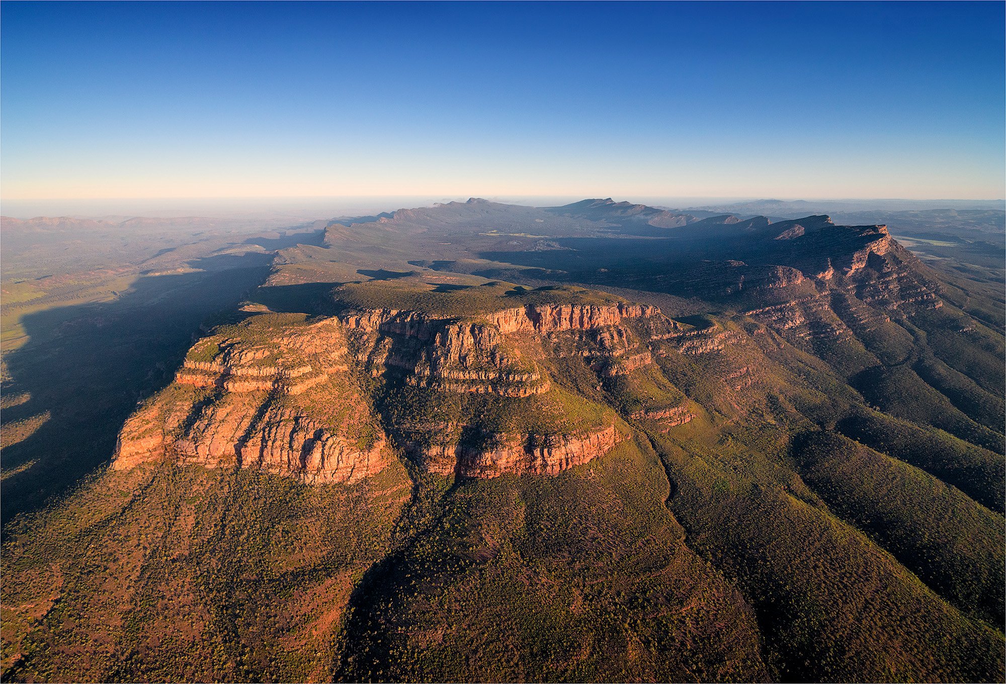
The Mt Lofty-Flinders Ranges are the dominant topographic feature of South Australia, extending from the southern tip of Fleurieu Peninsula to the far north of the state, a distance of around 800kms. Geologically, it is part of the Adelaide Geosyncline – a deep trough in which large amounts of sedimentary rock were deposited over 650 million years ago.
The folding and faulting that formed the range occurred some 540 million years ago – long before Australia became an individual landmass. Half a billion years of weathering have then shaped the ranges we see today: rolling hills and rugged, ragged escarpments. The highest mountain in the range is St Marys Peak (1,171m ASL), located adjacent to Wilpena Pound. Not such a high peak in a global setting.

The age and composition of the Flinders gives it its distinct geological features. The ranges are made up of a mixture of sedimentary rocks, such as the iron-stained sandstone which contain the rich red hues that are so familiar. Much of the high ground is capped with quartzites – a harder type of rock that erodes less easily. Ikara (Wilpena Pound) is perhaps the most well-known of such features. It’s a syncline formed by outcropping beds of Pound Quartzite, and was once thought by some to be a meteor crater. Other similar synclines in the ranges include the plateau of the Gammon Ranges – to the north of Ikara.
One small area within the ranges, the Ediacara Hills, is of global significance due to the discovery, in 1946, of fossil evidence of some of the oldest life forms on earth. In 2004 these fossils were included in a new geological period, the Ediacaran Period. The Ediacara fossils were the first of their type to be discovered and have since been found in other areas of the world. The Ediacaran Period spans over 90 million years from about 635 million years ago. The Ediacara biota contains some 100 genera of soft bodied organisms such as worms, fronds and disks but are quite distinct from the lifeforms of the Cambrian explosion that immediately followed this period.

Ediacara fossil
The weathering that reduced the ranges to their present state, revealing such amazing discoveries, also resulted in expansive plains to the east and west of the hills. Large salt lakes are scattered across these plains and include Lake Torrens, Lake Frome and Lake Callabonna with Kati Thunda (Lake Eyre) some distance to the north. Numerous river beds criss-cross their way through these plains and once carried water to these lakes.

Kati Thanda (Lake Eyre)
Apart from the occasional flooding rains, these rivers are now rarely active and haven’t been so for millennia. The average rainfall for this northern region is less than 250mm per annum, but very occasionally monsoonal showers sweep in and deposit this much in a day or two. While this region is semi-arid to arid with hot, dry summers and cool winters, the ranges closer to Adelaide around Mount Lofty have a distinctively different climate: they have what is often described as a Mediterranean climate.
First Residents
Despite being a harsh and arid environment, humans have occupied this region for at least 49,000 years. The oldest known site is Warratyi Rock-Shelter in the northern Flinders Ranges, adjacent to the Gammon Ranges. Artefacts, pigment and bone have been excavated from the area with archaeologists concluding that the site was occupied from about 49,000 years ago for at least 40,000 years. The people that used the shelter were hunter-gatherers who used a suite of stone tools to make spears and tools to kill and butcher their prey – including megafauna such as the rhinoceros-sized Diprotodon and Genyornis, huge emu-like birds that stood over 2m tall. They also used red and white pigment – possibly for body decoration or adorning cave walls.
The Andyamathanha - an aboriginal people of the Northern Flinders Ranges of whom Adam Goodes is perhaps the most well-known today - are the descendants of the first residents and still live in the area today. Their languages, art and Dreaming reflect their connection to Country and their occupation of it. In Flinders Ranges Dreaming, for example, the Gammon Ranges is the home of Arkaroo – the legendary great snake of creation and Ikara (Wilpena Pound) is the Andyamathanha word for ‘gathering place.’
Material evidence of Aboriginal occupation is widespread and includes scatters of stone tools through to camp sites in rock shelters. The most spectacular evidence is seen in displays of early art. The Andyamanthanha people practised both painting and engraving. Painted sites are scattered throughout the ranges but most are inaccessible to the public. Akaroo Rock has images painted in white ochre and charcoal that are over 6,000 years old. Yourambulla Cave has emu and kangaroo tracks drawn with charcoal.

Arkaroo Rock
Red Gorge contains hundreds of motifs engraved into the rock face. The majority depict animal tracks or the animals themselves with others forming lines and circles as well as abstract images from Dreamtime stories. Known as the Panaramitee Style, these images were produced by pecking the rock surfaces with a pointed stone. The first examples of this art style were found on the Panaramitee Station on the eastern flank of the Flinders Rages.
Some associations with places are more tragic: Arta-Waralpanha (Mt Serle) features prominently in the history of the Anyamathanha people – it was one of the largest campsites until European settlement forced the original inhabitants to live in camps adjacent to Mt Serle Station. Many Andyamathanha people live on Country and are actively involved in the management of local national parks (including Ikara and Vulkathanha), and some stations, including Arta-Waralpanha Station, have been returned to the traditional owners.
European Settlement
The first Europeans to visit this vast area were explorers, on a quest to find land suitable for farming, who moved north from Adelaide after it was settled in 1836. Edward John Eyre (after whom Lake Eyre was named) explored to the north of Spencer Gulf in 1839; he was followed, in 1846, by John Horrocks who sought to survey the ranges around Lake Torrens. Included in the party was Harry, the first camel to be brought to Australia. The party had only travelled a short distance when Horrocks was wounded after his shotgun accidentally discharged when the camel moved during re-loading. The expedition was abandoned and the party returned to Horrock’s property at Penwortham. Sadly he died one month later, and is the only explorer to have been shot by his camel.

Horrocks first interview (1868) by S. T. Gill - National Library of Australia
Squatters moved into the lower Flinders Ranges in the mid-1840s with sheep stations being established at Wilpena, Arkaba, Aroona and Kanyaka by the 1850s. Others tried growing wheat, but crops repeatedly failed in the 1850s and early 1860s as they were too far north. The Government responded by requesting the Surveyor-General, George Goyder, to create a boundary across the state to delineate those areas that received enough rain to support agriculture and those that did not. Goyder rode over an estimated 3,200kms on horseback and in December 1865 produced a report and map with the results of his survey. The map he published contained what is still known as ‘Goyder’s Line’, which delineated areas of arable land from those that were subject to drought. He based his findings largely on the vegetation he observed growing across these regions.

In the 1870s there was a concerted effort to move north of Goyder’s Line to grow wheat. History has revealed that this was a relatively short period of above average rainfall. After a few years, the rainfall returned to its normal, irregular pattern and crops failed. As a result, the region is dotted with settlements that lasted only a few years at best. Goyder was found to be a good judge of arable land and until the recent introduction of new strains of wheat, no crops were grown with any regularity north of his Line.
Farming wasn’t the only enterprise undertaken in the region. In the decades following the settlement of South Australia, copper was discovered north of Adelaide. The boom that followed saved the colony from bankruptcy, and prospecting extended well beyond the copper deposits around Kapunda, Burra and Kadina into the Flinders Range. Ores were discovered in many locations - including traces of gold.
Blinman, north of today’s Ikara-Flinders Ranges National Park, was one of the few mines that was moderately successful. Copper ore was discovered there in 1859, and mining operations continued until 1918. Numerous other mines operated during the latter half of the 19th century with renewed efforts in the early 20th century. These enterprises failed in all but a few instances, due to the lack of water for processing and the high cost of transport to these remote areas. Today, the landscape is littered with the evidence of either prospecting or failed mining efforts.
The Heysens
The lack of success of these enterprises has a silver lining. The spectacular landscapes of the Flinders were well preserved in 1923, when Sir Hans Heysen, one of Australia’s most famous landscape painters, first travelled to the area. He was among the first non-indigenous artists to study these landscapes and the Flinders Ranges became his favourite subject – he returned for another 10 painting expeditions, in which he captured the essence of the uniquely Australian landscape.

Sir Hans Hessen, Flinders Ranges landscape, 1956, National Gallery of Victoria, Melbourne
His paintings, with their wondrous hues and subtle plays of light, have attracted people to the area ever since. Although he was there to paint rather than walk, the ‘Heysen Trail’ trail through the Flinders is one of Australia’s iconic walking trails, capturing the essence of the continent from its geological formation to its tens of thousands of years of art and human history.
Flinders & Tourism
Today, the thriving economy in this region is supported by tourism. Apart from its rugged beauty, the area attracts visitors for a myriad of reasons – amazing and often unique flora and fauna; its Aboriginal heritage and deep history; its European past including the ruins of abandoned sheep stations along with working properties that encourage visitors; mining settlements and towns; but also the clear skies, sweeping landscapes and the wonderful people that still call the Flinders their home.

Tour Adelaide & The Flinders Ranges
An Outback Adventure with Dr Chris Carter
Forming one of Australia’s iconic outback journeys, take the road less travelled in 2023 and experience stunning outback landscapes, Indigenous culture and the unique geological formations of the Flinders Ranges on our 12-day itinerary led by Dr Chris Carter.